


US Topo Maps
US Topo Mapsの説明
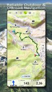
米国の利用可能な最高の地図と航空写真に無料でアクセスできる、使いやすいアウトドア ナビゲーション アプリです。
30 以上の地図レイヤー (地形図、航空写真、海図など) から選択して、完璧な旅行を計画し、
Android スマートフォン/タブレットを屋外 GPS として使用して、バックカントリーへのオフライン旅行に使用できます。
他のソース (GeoPDF、GeoTiff、WMS などのオンライン マップ サービスなど) からマップを簡単に追加します。
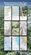
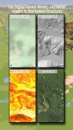
米国で利用可能なベースマップ層:
•USGS National Map Topo
•USGS National Map Imagery Topo
•USGSナショナルマップ画像
•USGS NAIPは画像を雇います
• USGS Topo 従来の DRG: 縮尺 1:250.000、1:100.000、1:63.000、および 1:24.000/25.000 で米国の地形図をシームレスにカバー
• FSTopo 森林マップ
•NOAAノーティカルRNCチャート
• 全国標高図 (陰影起伏図、傾斜角図、傾斜角図)
ワールドワイドベースマップレイヤー:
• OpenStreetMaps (5 つの異なるマップ レイアウト)、省スペースのベクター形式でもダウンロード可能
• Google マップ (衛星画像、道路地図、地形図)
• Bing マップ (衛星画像、ロードマップ)
• 夜の地球
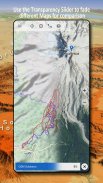
ベースマップ レイヤーをオーバーレイとして構成し、透明度フェーダーを利用してマップを相互にシームレスに比較します。
他のソースからマップを追加します。
•GEOPDF、Geotiff、MBTILESまたはOZI(OziexPlorer OZF2&OZF3)にラスターマップをインポートします)
• Web マッピング サービスを WMS または WMTS/Tileserver として追加する
• OpenStreetMaps を Vector 形式でインポート(例: 完全な米国を数 GB だけ)
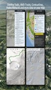
利用可能な米国地図オーバーレイ - 他のベース マップに追加情報を追加します。
•公有地の所有権(PAD-US 3)
•全国の水路データセット
•自動車使用マップ(USDA)
•標高の輪郭
• 4WDトレイル
• トレイル
• 道路、鉄道、空港
世界中で利用可能なオーバーレイ:
• 陰影起伏オーバーレイ
• 20mの等高線
• オープンシーマップ
完璧な地図はありません。さまざまなマップ レイヤーを切り替えるか、マップ比較機能を使用して、最も興味深いルートを見つけます。特に、古い伝統的な DRG には、現代のマップには欠けている小さなパスやその他のフィーチャが多数含まれています。
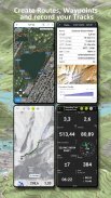
屋外ナビゲーションの主な機能:
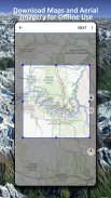
• オフラインで使用するための地図データをダウンロードする
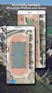
• 経路とエリアを測定する
• ウェイポイントの作成と編集
• GoTo-ウェイポイント-ナビゲーション
• ルートの作成と編集
•ルートナビゲーション(ポイントツーポイントナビゲーション)
• トラック記録 (速度、高度、精度プロファイル付き)
• 走行距離計、平均速度、方位、標高などのフィールドを備えた Tripmaster。
•GPX/KML/KMZインポート/エクスポート
•検索(PlaceNames、Pois、Streets)
•標高と距離を取得します
• マップビューとトリップマスターのカスタマイズ可能なデータフィールド (速度、距離、コンパスなど)
• ウェイポイント、トラック、ルートを共有(電子メール、Dropbox、WhatsApp など経由)
• WGS84、UTM、または MGRS/USNG (Military Grid/US National Grid) の座標を使用します。
• トラックの再生
• などなど ...
このナビゲーションアプリを使用して、ハイキング、サイクリング、キャンプ、登山、乗馬、スキー、カヌー、狩猟、スノーモービルツアー、オフロード4WDツアー、サーチ&レスキュー(SAR)などの屋外アクティビティを使用してください。
WGS84 測地系を使用した経度/緯度、UTM または MGRS/USNG 形式でカスタム ウェイポイントを追加します。
GPS ウェイポイント/トラック/ルートを GPX または Google Earth KML/KMZ 形式でインポート/エクスポート/共有します。
NEXRAD 雨レーダーのアニメーションを参照して、雨がいつ降り始めるか、いつ止むかを正確に予測します。
質問、コメント、機能リクエストを support@atlogis.com に送信してください。
US Topo Maps - バージョン 7.8.0
(08-05-2025)US Topo Maps- APK情報
APKバージョン: 7.8.0パッケージ: com.atlogis.northamerica.freeUS Topo Mapsの最新バージョン
他のバージョン


同じカテゴリのアプリ


